Precision Timing and Data Fusion: Why Synchronization Makes or Breaks Mobile Mapping
Even the best sensors won’t deliver usable data if they’re out of sync.
We often talk about resolution, sharpness, and calibration when it comes to camera systems. However, in mobile mapping systems where camera, LiDAR, and other sensors operate side by side, none of it works unless everything is synchronized.
If your Global Navigation Satellite System (GNSS), LiDAR, and camera data are even slightly out of alignment, you’ll notice it right away: color shifts, drift between layers, and missing overlap. Fixing it later costs time, accuracy, and trust in your results.
Here’s what we’ve learned from mobile mapping teams that need reliable, clean data—especially when integrating multiple sensor types.
Let’s start with triggering: Time vs. distance
Not all systems trigger sensors or cameras the same way. For example, some capture frames based on time (e.g. every 100 milliseconds). That might work for video, but in a mobile mapping system, your vehicle speed changes constantly. What you really need is consistent distance between frames, so you capture the scene evenly, without gaps or unnecessary overlap.
That’s where Distance Measuring Instruments (DMIs) come in. By sending pulses based on ground distance traveled rather than fixed time intervals, you get more uniform coverage and consistent overlap, regardless of speed.
Pair that with Pulse Per Second (PPS) signals from a GNSS receiver, and now you’ve got a way to align every captured frame (image, point cloud, Inertial Measurement Unit (IMU) data) to a single, precise moment in time and space.
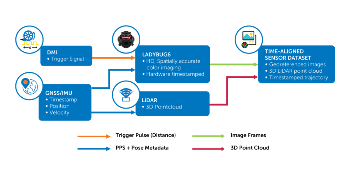
This ensures that each image corresponds to the same physical location as the LiDAR and positional data it’s paired with—frame by frame, pulse by pulse.
Why Sync Drift Is a Real Problem
Here’s what happens when timing isn’t tight:
- Your LiDAR scan captures a utility pole, but the corresponding image is delayed, making it difficult to associate texture or color with each 3D point.
- Your image timestamp doesn’t match the GNSS position, leading to incorrect geolocation.
- Your IMU data reports a different vehicle orientation than when the camera was triggered and causes projection or errors in the combined dataset.
- Your colorization in the point cloud becomes inaccurate, and segmentation software starts to misclassify features.
Even a small drift such as 10 to 20 milliseconds can create cascading issues. It leads to reprocessing, manual correction, or data that simply doesn’t meet spec.
Timing precision = Cleaner data and less post processing
Tightly synchronized systems don’t just capture better data. They also make your entire process faster.
When images are triggered precisely, and each one is timestamped cleanly, alignment with GNSS and LiDAR becomes straightforward, point cloud colorization is more accurate, and scene segmentation is more reliable. Post-processing workflows also run smoother and have fewer exceptions to manually fix or patch.
In mobile mapping systems where data volumes are huge and delivery deadlines are tight, sync integrity reduces risk and rework.
What we recommend asking when evaluating sync performance

Here are the practical questions we see technical teams asking before choosing a camera system:
- Can it accept external triggers like DMI and respond without delay?
- Does it timestamp frames at the hardware level for reliable alignment?
- Will it maintain synchronization over long survey missions without accumulating drift?
- Can it integrate cleanly with LiDAR, GNSS, and IMU data without requiring extensive post-capture adjustment?
- Has it been used successfully in real-world mobile mapping applications?
If the answer to any of these is unclear, it’s likely to show up in your processing pipeline.
We’ve seen these questions separate systems that just function from those that perform consistently across projects and platforms.
Why it matters in the field
Sync isn’t a lab spec—it’s a system-level enabler. When it’s done right, your mobile mapping platform delivers high-integrity data that’s easier to trust, analyze, and deliver.
When it’s not done right, you lose time, accuracy, and confidence.